
Kakochang Waterfall
"A stunning multi-tiered waterfall cascading down the Karbi Anglong foothills near Bokakhat"
Kakochang Waterfall (locally known as Keipholangso Falls) is a multi-tiered waterfall situated near Naharjan Gaon in the Golaghat District of Assam, at an elevation of 120 meters above sea level. Located about 13 km from Bokakhat and 30 km east of Kaziranga's Kohora range, this 40-meter cascade originates in the Karbi Anglong hills. The waterfall is open throughout the year and is a popular active excursion for visitors exploring the national park.
Approaching the Hidden Plunge Pool
You will hear the waterfall long before you see it. Walking through the dense canopy, the hum of forest cicadas and the scent of wild ginger fill the air. The trail leads to a cool, rock-strewn plunge pool where the cascade plunges down dark basalt cliffs. Standing on the right side of the waterfall, you will experience sudden, high-velocity winds and heavy spray—an exciting, high-energy phenomenon that is completely absent on the calmer left side.
Natural Ecology & Geology
The waterfall originates from highland springs in the Karbi Anglong plateau, carving its path through geological formations of Precambrian basalt rocks. The forest is characterized by tropical semi-evergreen vegetation, home to unique native bird species such as the Great Indian Hornbill and various kingfishers. Thick groves of native Bhaluka bamboo (Bambusa balcooa) drape the stream banks, creating a humid microclimate where wild ferns and epiphytic orchids cling to the trees.
Trail Access, Vehicles, and Community Bridges
The journey begins at the entry gate, where the trail technically starts. However, vehicles are permitted to drive 2 kilometers further to the main parking area. Past this parking area, no vehicles are allowed. From the parking lot, visitors walk on foot. While there is a well-furnished resort with accommodation and a restaurant situated just across the first stream after the parking lot, the trek to the falls continues deeper into the forest.
Previously, this trek was highly challenging as visitors had to wade directly through several shallow mountain streams. Over time, simple bamboo bridges (sako) were added, but today the local community has constructed sturdy iron bridges across the streams and over the rugged rock paths. This modern infrastructure makes the lower trail highly accessible and safe for everyone, including children and elderly travelers. Visitors can still choose to cross the shallow streams on foot, which is considered a fun and refreshing experience.
The Upper and Lower Trails
After crossing the first few streams on foot, the trail splits into two distinct paths that both lead to the falls. You can make it a round trip by exploring both routes:
- The Lower Trek: This route was cleared and developed by the local community specifically for general tourists. It is flat, runs along the valley floor, and is comparatively very easy to walk.
- The Upper Trek: This is the original path. It is a harder route that requires climbing up a steep forested hill. For adventure seekers, this is an exciting climb, but caution is required on the final descent to the waterfall: the dirt steps are very narrow, and the bamboo safety railings may naturally wear off due to exposure to the elements.
Local Bamboo Cuisine and Trailside Eats
At the trailhead parking area, small local shops and stalls offer tea, bottled water, souvenirs, and local produce. Here, you can try traditional local tribal delicacies, such as pork and chicken seasoned with local herbs, stuffed into hollow green bamboo stems, and slow-cooked over open wood fires. A few small snack and beverage stalls are also scattered along the trail for refreshments.
Getting There
The trailhead is reached via a narrow road off National Highway 37 from Bokakhat. To reach the entry gate, you must drive through the beautiful, sprawling Naharjan Tea Estate, whose manicured green tea bushes line the route. If you are traveling on our 9-day wildlife and gorge tour or the 7-day Kaziranga and Tawang journey, Kakochang is a perfect active morning excursion. The nearest major town is Bokakhat (13 km), Jorhat Airport is 65 km away (1.5 hours by road), and Furkating Junction in Golaghat is 40 km away.
Insider Tips
- Experience the wind tunnel: Walk to the right side of the waterfall pool to feel the dramatic, high-velocity winds created by the cascade—the left side of the pool is completely calm.
- Drive to the inner parking lot: Save energy by driving the 2 km from the entry gate to the inner parking area before starting your walk on foot.
- Try bamboo-cooked chicken: Stop at the parking lot stalls to try chicken or pork slow-cooked inside green bamboo stems, a unique local tribal delicacy.
- Choose your trail wisely: Take the steep, hilly upper trail to the falls for an adventurous climb, and return via the easy, flat lower trail to complete a scenic loop.

7-Day Tawang Tour Package from Guwahati: Dirang, Sangti & Shergaon
Mountains & Monpas: A Curated Himalayan Journey
Visitor & Booking Protocol
Permit & Entry Check
No special state permit required for Indian citizens. Keep government photo ID ready at entrance.
Tickets & Cash Protocol
Entry desk is managed on-site. Carry small cash denominations (₹20, ₹50, ₹100) for entry and parking.
Certified Guide Desk
Authorized village community guides can be hired at the entry registration desk. Certified guide rates range between ₹800–₹1,500 depending on circuit and trail duration.
Timing & Departure Cutoff
Arrive during early morning hours (08:00–10:30 AM). Mountain trails, caves, and viewpoints generally stop inbound entry by 15:30 to ensure safe return before mountain dark.
Safety & Rules
- • Check safety rails on the upper trail: If taking the hilly upper route, exercise extreme caution on the final descent as the bamboo safety railings can naturally decay and wear off.
- • No vehicles past the inner parking: Park all two-wheelers and cars at the community parking lot; only pedestrian traffic is allowed beyond this point.
- • Respect local food stalls: Do not litter wrappers or cups along the trail; use the disposal bins provided at the trailside eatery stalls.
- • Avoid the deep center pool: Do not swim or wade directly under the main 40-meter fall, as strong down-draft undercurrents and submerged rocks present extreme hazards. Multiple tragic drowning incidents have occurred here in recent years (reported by Sentinel Assam), especially when water levels rise due to heavy rains upstream.
Frequently Asked Questions
More Places to Visit in Kaziranga
Handpicked stops our drivers pass every week.

Jeep Safari in Western Range, Kaziranga
The ultimate destination for One-horned Rhino sightings.
67m ASL

Jeep Safari in Central Range, Kaziranga
Ride through the core marshy floodplains of the Kohora range.
65m ASL

Jeep Safari in Eastern Range, Kaziranga
Quiet woodlands and exceptional birding around Sohola Beel.
80m ASL

Jeep Safari in Burapahar Range, Kaziranga
Track Hoolock Gibbons and Capped Langurs through hilly broadleaf forests in Kaziranga's remote westernmost beat.
75m ASL

Elephant Safari in Western Range
Dawn patrol on elephant-back to track rhinos closely in Bagori.
67m ASL
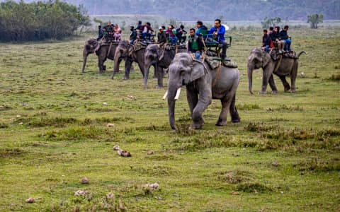
Elephant Safari in Central Range
Track wild rhinos silently at sunrise from the Mihimukh riding tower.
65m ASL
Best Time to Visit
Best time of day: Daylight hours (07:00 AM - 03:00 PM)
Visitor Specs
Subject to daylight and weather conditions. Last entry by 03:00 PM. Note: Crowds are moderate in general, but become high on weekends and holidays.
How to Reach
Altitude & Terrain
120m
7-Day Tawang Tour Package from Guwahati: Dirang, Sangti & Shergaon
Mountains & Monpas: A Curated Himalayan Journey
Location
Lng: 93.630000
Plan Your Trip to Kaziranga with Nezo
Combine Kakochang Waterfall with living tribal heritage, scenic mountain vistas, and handpicked local stays on a private guided journey.