
Sela Pass
"Dramatic high-altitude mountain pass and the sacred gateway to Tawang"
Sela Pass (Sela La) is a high-altitude mountain pass located on the border between West Kameng and Tawang districts of Arunachal Pradesh, at 4,170 meters (13,700 feet) above sea level. Serving as the primary gateway to Tawang town, it is famous for its twin glacial lakes (particularly Sela Lake) and the engineering marvel of the newly completed Sela Tunnel.
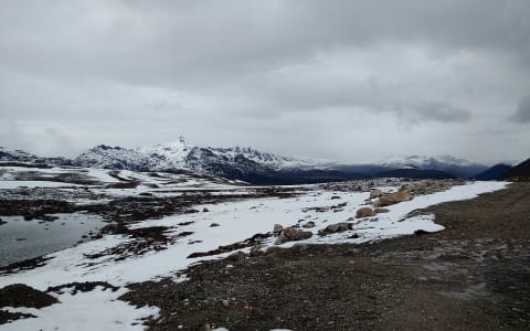
At the summit, the piercing mountain wind, sharp and thin with the scent of frozen earth and glacial water, howls incessantly through a colorful gateway of Buddhist prayer flags. Below, the sprawling turquoise waters of Sela Lake lay partially frozen, its icy crust glistening like shattered glass under a cold, brilliant Himalayan sun. Rated 4.8/5 on Google Maps with 3,500+ reviews, it remains one of the most photographed and strategically crucial mountain crossings in India.
History, Legend, and the Sacred Lakes
Sela Pass is sacred ground in both Monpa Buddhist tradition and modern Indian military history. According to Monpa and Tibetan Buddhist beliefs, the greater Tawang region is home to exactly 101 sacred high-altitude lakes, each protected by a local guardian deity. Sela Lake (often called Paradise Lake) sits right at the summit and is one of the most revered. Pilgrims and traveling monks frequently stop by its shores to offer prayers and hang fresh prayer flags, believing that the freezing waters hold deep spiritual cleansing properties.
In modern history, the pass is forever linked to the 1962 Sino-Indian War and the legend of Rifleman Jaswant Singh Rawat of the 4th Garhwal Rifles. Standing against advancing Chinese forces at the Battle of Nuranang, Jaswant Singh reportedly held off the enemy single-handedly for 72 hours by firing from multiple positions to make them think a large platoon was defending the post. Local legend holds that two Monpa girls, Sela and Nura, helped him by carrying food and ammunition under gunfire. After Jaswant's heroic death, Sela leaped from a high ridge to avoid capture. The pass and the sacred lake were subsequently named "Sela" to honor her ultimate sacrifice. Today, the Jaswant Garh War Memorial stands just 14 km further along the route, serving as a highly venerated site where travelers stop to pay their respects.
The Sela Tunnel: An Engineering Revolution
For generations, crossing Sela Pass was one of the most hazardous parts of the journey to Tawang. Heavy winter snowfalls regularly blocked the road for weeks, and severe fog and landslides during the monsoon cut off the strategic frontier from the plains of Assam. To resolve this perennial challenge, the Border Roads Organisation (BRO) undertook the construction of the monumental Sela Tunnel system under Project Vartak.
Formally inaugurated on March 9, 2024, the project consists of two main tunnels: Tunnel 1, a 980-meter single-tube tunnel, and Tunnel 2, a 1,555-meter twin-tube tunnel equipped with an emergency escape passage. Built using the advanced New Austrian Tunnelling Method (NATM) through highly unstable tectonic zones at an altitude above 13,000 feet, the Sela Tunnel is a triumph of modern engineering. It bypasses the most treacherous, landslide-prone heights of the pass, reducing travel times by over an hour and ensuring reliable, all-weather connectivity for both civilians and defense logistics.
Ecology and High-Altitude Biodiversity
The environment of Sela Pass is characterized by its fragile alpine and sub-alpine ecosystems. Because of the extreme altitude and freezing winds, tree growth is sparse at the summit, dominated by dwarf willows, alpine grasses, and low-growing mosses. However, as the elevation drops slightly, the slopes burst into spectacular displays of alpine flowers. In late spring and early summer, the pass is decorated with wild species of Rhododendron, Primula, and high-altitude blue poppies.
The surrounding valleys are part of the Eastern Himalayan biodiversity hotspot, providing a habitat for rare, elusive wildlife. The endangered Musk Deer (Moschus chrysogaster) and the Himalayan Goral roam the rocky crags, while the dense conifer forests below harbor Red Pandas. Birdwatchers can spot high-altitude avifauna like the Blood Pheasant and Blyth's Tragopan navigating the steep slopes.
Getting There: Navigating the High Highway
To reach Sela Pass, you will travel along National Highway 13 (the Trans-Arunachal Highway). If departing from the plains of Assam, the journey typically starts in Guwahati, driving roughly 340 km to the town of Dirang, where we recommend travelers halt for at least one night to acclimatize. From Dirang, the ascent to Sela Pass takes about 1.5 to 2 hours over a 50 km winding stretch of mountain roads.
If you are traveling from Tawang town, the pass is approximately 73 km away, taking about 2 hours by road. Nezo exclusively utilizes company-owned, rigorously maintained 4x4 SUVs driven by local veterans with zero-complaint records to ensure absolute safety on these challenging, high-altitude curves. This journey is a core segment of our 7-day Arunachal tour package, which guides you from Guwahati up to the spiritual heart of Tawang.
What NOT to Expect
Do not expect a commercialized tourist hub with cozy restaurants, luxury hotels, or souvenir markets. Sela Pass is a remote, high-altitude mountain pass with a heavy military presence. The weather is volatile and can turn freezing within minutes, even in mid-summer. There are no ATMs or fuel stations at the summit. Aside from a single military canteen adjacent to the Sela Pass welcome gate selling hot tea, instant noodles, rum (liquor), and light snacks, facilities are practically non-existent.
Most importantly, do not expect clean or functional public restrooms. While there is a single toilet facility near the pass welcome gate (located opposite the military canteen across the road), during the sub-zero winter and snow seasons, the lack of running water and freezing temperatures mean urine and waste freeze solid immediately. The facility becomes severely unhygienic, often forcing visitors to step over patches of icy waste with no way to wash. It is highly recommended to use the cleaner facilities at the Baisakhi military camp before ascending, or wait until reaching the Jaswant Garh War Memorial canteen further down. Finally, stopping inside the new Sela Tunnel or parking near its entrance is strictly prohibited for safety and security.
When Is the Best Time to Visit?
The experience of Sela Pass changes dramatically with the seasons:
- Winter (November to February): The weather is harsh, freezing, and dominated by heavy snowstorms. Temperatures regularly drop to −15°C, and Sela Lake is completely frozen. While the new Sela Tunnel ensures the road remains open, the old pass route can be blocked by heavy snow. Thermal clothing and heavy winter wear are mandatory.
- Summer (March to June): The best time to experience the thaw. The ice on Sela Lake begins to melt, revealing clear turquoise waters, and rhododendrons bloom in the valleys. Temperatures range from 5°C to 15°C.
- Monsoon (July to September): The region receives heavy rains, which often cause landslides and heavy fog on the approach roads. The landscape is lush green, but travel during this period is highly unpredictable and caution is advised.
- Autumn (October to November): The air is crisp, dry, and exceptionally clear post-monsoon, offering stunning panoramic views of the surrounding peaks. The water in the lake is a brilliant blue.
Photography Guide
- "I Love Sela" Signboard: Stand directly in front of the colorful "I ❤️ Sela" signboard located near the summit, with the sweeping waters of Sela Lake and the wide Himalayan sky creating a dramatic backdrop.
- Sela Lake Shoreline: A designated parking bay along the lake offers a safe spot to capture the reflection of the snow-covered peaks in the still, clear waters of the lake.
- The Sela Gateway: The colorful, traditional Buddhist archway at the summit of the pass, adorned with prayer flags, serves as the classic marker for travelers.
- Sela Tunnel Portal: The grand concrete entrance of Tunnel 2, framed by the rugged, snow-dusted mountainside, offers a dramatic architectural shot representing modern infrastructure.
Insider Tips
- Acclimatize in Dirang: Spend at least one full night in Dirang (4,900 ft) before ascending to Sela (13,700 ft) to dramatically reduce the risk of altitude sickness.
- Start at dawn: Leave Dirang by 5:00 AM or Tawang by 6:00 AM to cross Sela Pass when the morning skies are clearest and fog has not yet rolled in.
- Bring physical cash: Digital network coverage is non-existent at the summit, so bring cash to buy hot Maggi or tea from local vendors.
- Layer your clothing: Wear multiple thin layers (thermal innerwear, fleece, and windbreaker) rather than a single heavy coat, as the wind chill changes rapidly.
- Carry medication: Keep motion sickness pills (for the sharp hairpins) and Diamox (for altitude) in your daypack.
- Keep camera batteries warm: Extreme cold drains batteries quickly; store spares in an inner pocket close to your body heat.
- Stop at Jaswant Garh: Pull over at the Jaswant Garh War Memorial canteen just past the pass for hot, army-brewed tea and clean restrooms.

6-Day Tawang Tour Package from Guwahati: Sela Pass & Bum La
High Passes, Sacred Lakes & Monpa Frontier
Visitor & Booking Protocol
Permit & Entry Check
State permit / ILP verification required at highway checkpost before arrival.
Tickets & Cash Protocol
Entry desk is managed on-site. Carry small cash denominations (₹20, ₹50, ₹100) for entry and parking.
Certified Guide Desk
Authorized village community guides can be hired at the entry registration desk. Certified guide rates range between ₹800–₹1,500 depending on circuit and trail duration.
Timing & Departure Cutoff
Arrive during early morning hours (08:00–10:30 AM). Mountain trails, caves, and viewpoints generally stop inbound entry by 15:30 to ensure safe return before mountain dark.
Safety & Rules
- • No stopping inside the tunnel: Stopping or exiting your vehicle inside any part of the Sela Tunnel is strictly prohibited except in an emergency.
- • No photography of military assets: Do not photograph army checkpoints, bunkers, vehicles, or personnel around this sensitive border zone.
- • Never walk on the frozen lake: The ice sheet can be deceptively thin. Walking on it is strictly banned due to fatal drowning hazards, including a tragic incident in January 2026 when two tourists from Kerala lost their lives after the ice collapsed while trying to rescue a companion (read the NDTV report).
- • Yield to army convoys: Indian Army trucks have absolute right of way; safely pull over to the side to let them pass.
- • Keep headlights on: Always turn on your headlights when entering the Sela Tunnel and driving through thick fog.
- • Do not litter: Carry all trash back to Tawang or Dirang; Sela Lake is sacred to the local Monpa Buddhist community.
Frequently Asked Questions
More Places to Visit in Tawang
Handpicked stops our drivers pass every week.

Bum La Pass
The historic and rugged high-altitude frontier connecting India and Tibet
4633m ASL
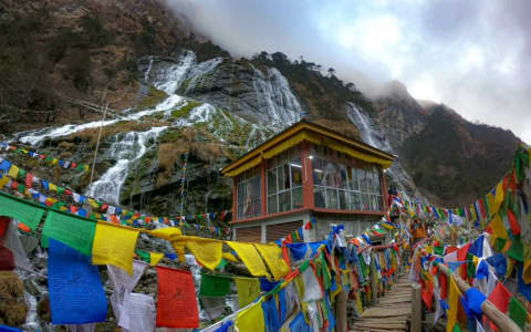
Chumi Gyatse (Holy Water Falls)
108 Sacred Cascades on the Edge of the Tawang Frontier
3505m ASL

Nuranang Falls
A spectacular 100-meter drop waterfall famously known as Jang Falls or Madhuri Falls
1828m ASL

Sangetsar Tso (Madhuri Lake)
The hauntingly beautiful high-altitude lake of frozen pine trunks at 12,165 feet
3708m ASL

Tawang War Memorial
Namgyal Chorten - Tribute to the brave martyrs of the 1962 Sino-Indian War
3000m ASL
Gribtsang Tso (Nagula Lake)
The Sacred Alpine Mirror of the Bumla Sector
Best Time to Visit
Best time of day: Morning
Visitor Specs
Open 24 hours, but daytime travel is highly recommended due to high-altitude driving hazards.
How to Reach
Altitude & Terrain
4,170m (13,700ft)
6-Day Tawang Tour Package from Guwahati: Sela Pass & Bum La
High Passes, Sacred Lakes & Monpa Frontier
Location
Lng: 92.103300
Plan Your Trip to Tawang with Nezo
Combine Sela Pass with living tribal heritage, scenic mountain vistas, and handpicked local stays on a private guided journey.